
Dempster Highway is the only road in Canada that can take you all the way to the Arctic Ocean. That’s right, the only one! Before I came here, I thought a developed country like Canada would have roads going to every corner of the country. After I visited this region, the Yukon Territory and the Northwest Territory where the Dempster Highway goes through, I learned that there are a lot of communities here can only be reached by flying or boating.


The Dempster Highway is a 919 km of gravel road. When we told the people we met on the way that we were planning on hitchhiking all the way to the end of the road, they were all shocked. It would take about 15 hours to drive straight there, so it’s going to be significantly slower adding on the waiting time for hitchhiking. Well, we don’t have a car and we don’t have money to fly (hundreds of dollars!). We don’t have many other options. It’s summer and we have a tent.
The whole Dempster Highway has stunning views all the way through. The amazing scenery is dished out in such a large scale which makes it even more breath-taking. There aren’t many services on this highway, so everyone that’s going on this road has to be extra prepared: extra food, fuel, and spare tires.
Dawson City to Eagle Plains (About 405km)


Dawson City, the beginning of the Dempster Highway, has 2-3 grocery stores and many restaurants and hotels. It feels pretty touristy. However, Eagle Plains only has one single hotel and one single restaurant. There isn’t any stores or gas stations between Dawson City and Eagle Plains
The scenery along the Dempster Highway makes me WOW the whole way. The most (only?) famous tourist attraction along the highway is the Tombstone Territorial Park. What a gloomy name, I thought. When I saw the view though, WOW. There are a lot of open valleys, streams and creeks, and lakes. It’s so, truly amazing.


Eagle Plains to Fort McPherson (About 182km)
Eagle Plains has only one restaurant and one hotel. There is a gas station as well. In Fort McPherson, there is a store, a gas station, and some other shops that really aren’t clear if they are open or not.
After we left the Tombstone Territorial Park, there isn’t any other famous tourist sites, but the view is still super stunning all the way through. It’s the first time I experience going somewhere so remote. The wilderness in northern Canada is so huge! I bet if I get out of the car and get lost in the wilderness here, no one would be able to find me in 10 years. I feel like a little ant in this vast, open land. Many people are on the lookout for caribous, lynxes, grouses, or moose. We didn’t have much of luck seeing lots of them, but we did see some grouses, a grizzly bear crossing the road, arctic ground squirrels, and a moose. Too bad we didn’t see any lynx!


Fort McPherson to Inuvik (About 186km)
Inuvik is a little town that has around 3000 people, which is considered a big town on the Dempster Highway. There are quite a few hotels and restaurants. There’s also a self-service car wash place.
You’ll need to cross two ferry stations on this stretch. The ferry stations might close due to bad weather so it’s always good to check ahead of time. The ferry isn’t big at all. It carries around 5-6 cars each time. I’m so curious about if the tanker trucker, Kelly, who picked us up earlier when we were hitchhiking, really got on the ferry. He must have though, because this is the only road. In winter, the river will freeze so the cars just drive on ice over to the other side.

Inuvik to Tuktoyaktuk (About 149km)
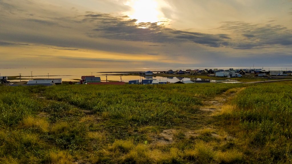
Tuktoyaktuk is the town that is at the end of the road, the end of the Dempster Highway! It’s so hard to imagine that people who live here had to fly every time they wanted to leave the town until 2017. Tuktoyaktuk is a town of about 900 people. There is a gas station, around 5 B&Bs, and about 3 restaurants.


We were told that the construction of this road was challenging. They had to take into account that there is permafrost underneath. If they melt the permafrost during the construction, it’s going to lead to some collapse. Also, it’s going to make the road really bumpy. Part of their solution was to raise the road with gravel (1.2 meters or more) to add some insulation between the surface of the road and the permafrost. I never thought about the relationship between permafrost and road-building. I was happy that someone thought of that!
The Dempster Highway goes through subarctic and arctic climate zones – the terms that only meant something to me in my high school geography class! In the beginning of the highway, in the subarctic, you can see some tiny forests. After Inuvik, in the arctic climate zone, there is only tundra. Fun fact about me: When people told me the name “tundra” in Enlgish, I was like, okay, I’m gonna see some tundra. That’s cool. When I finally looked up the word in Chinese, which is “凍原-Dongyuan,” I was like, WHAT, I’m gonna see WHAT? I was SUPER excited. It was like I finally knew what it really meant! Guys, this shows the importance of the education of your native tongue!


Before you get on the Dempster Highway, you’d better fill up on gas and bring extra food, unless you’re ready to pay for 15-30 Canadian dollars per meal per person.


The last but not least, I was happy to find out that I wasn’t the first Taiwanese person that came to Inuvik!

Follow Super Mei!
Sign up for our emails on top of the website! Also, check out Super Mei’s Instagram!